3 Days in Big Sur
Michael Reynolds • 15 Jan 2026 • 138 views • 5 min read.You think three days in Big Sur captures the experience—Highway 1 scenic drive, McWay Falls photo, Bixby Bridge done. Reality? Big Sur demands accepting three days barely scratches surface where 90-mile coastline (Carmel south to Hearst Castle north—no incorporated town just scattered lodges/restaurants/campgrounds, 4,000 residents fiercely protective, Santa Lucia Mountains drop 5,000 feet ocean creating dramatic cliffs, Highway 1 most scenic drive America designated National Scenic Byway 1965), infrastructure fragile (one road Highway 1 closes winter storms/landslides frequently 2017 Pfeiffer Canyon Bridge collapsed 13-month closure isolated community, 2021 washout Rat Creek, cell service spotty AT&T/Verizon weak pockets only Verizon better, gas stations two only Carmel Highlands north $6-$7/gallon Gorda south limited hours, restaurants 15 total expensive $25-$50 entrees captive market), and costs explode where budget travelers struggle $200-$300 daily minimum (campgrounds $35-$75 national/state parks advance reservations essential sells out months summer, lodges $300-$1,200/night Ventana/Post Ranch Inn luxury $1,500-$3,000 Big Sur Inn budget $200-$400, food limited options $20-$40 meals Nepenthe iconic $25 Ambrosia burger, no grocery stores bring supplies Monterey/Cambria stock up). You experience natural beauty unparalleled (McWay Falls 80 feet waterfall drops beach Julia Pfeiffer Burns State Park $10 parking photogenic cove turquoise, Bixby Bridge 1932 concrete arch 714 feet span 260 feet above creek Instagram famous vista pullout north side, Pfeiffer Beach purple sand garnet mineral $12 parking Sycamore Canyon Road unmarked 2 miles gravel narrow keyhole rock arch sunset, Point Lobos State Reserve $10 sea otters kelp forests cypress trees wildflowers tide pools, Andrew Molera State Park beach trail 1 mile redwoods meadows secluded), redwood forests (Pfeiffer Big Sur State Park 1,006 acres hiking trails Big Sur River gorge redwood groves Valley View Trail moderate 2 miles elevation 300 feet, Julia Pfeiffer Burns Ewoldsen Trail 4.5 miles loop redwoods ocean overlooks 1,600 feet elevation challenging), spiritual vibe (Esalen Institute $170-$3,000 workshops hot springs clifftop baths midnight-1:00am public access $40 reservations required online sells out days advance, New Camaldoli Hermitage Benedictine monastery retreat bookstore fruitcake famous, Henry Miller Memorial Library $5 suggested donation Beat Generation author lived here 1944-1962 bookstore community hub free WiFi concerts)—but brutal truth: Big Sur demands accepting extreme isolation (90 miles no towns just lodges/campgrounds scattered, nearest grocery store Carmel 25 miles north or Cambria 60 miles south, emergency helicopter only Monterey hospital 45 minutes trauma serious, Highway 1 closes unpredictably winter check Caltrans 511 before departing), narrow winding road (25-35 mph average speeds, blind curves hairpin turns, cliffs 500+ feet drops no guardrails, RVs/trailers discouraged 35-foot length maximum pull-outs required let traffic pass, motion sickness passengers common Dramamine recommended, 3-4 hours drive 90 miles versus freeway 90 minutes exhausting concentration), weather unpredictable (summer fog marine layer blankets coast mornings June-August burn off 11:00am-1:00pm or persist all day, spring wildflowers April-May optimal, fall September-November warmest clearest, winter December-March rain/landslides/closures 50-80 inches annually), costs crush budgets (lodges $300-$1,200 average $500-$800, camping $35-$75 if lucky reserve, gas $6-$7 Carmel Highlands versus $5 Monterey 10 miles north markup 20%+, restaurants $25-$50 entrees captive audience), and recognition 90-mile stretch fragile ecosystem protected development restricted California Coastal Commission permits difficult zoning strict residential density 1 dwelling per 20-40 acres preserved but accessibility limited—three days shows highlights but exploring trails beaches properly requires weeks locals spend lifetimes discovering hidden spots never publicize protecting sacred. The truth: Big Sur offers unparalleled coastal beauty, redwood forests, spiritual isolation—but demands accepting extreme costs $1,000-$2,500 three days, infrastructure fragile one-road isolation, narrow winding Highway 1 exhausting, and understanding 90-mile coastline trails depth requires weeks return wilderness pilgrimage.
3 Days in Big Sur 101: Perfect Itinerary, Costs, and Brutal Truths
Day 1: Carmel to Bixby Bridge to Pfeiffer Big Sur State Park
Understanding Day 1 priorities:
Morning: Carmel-by-the-Sea Starting Point + Point Lobos (7:00am-11:00am)
Carmel-by-the-Sea: Gateway north (Ocean Avenue—upscale village galleries/boutiques/restaurants, fairy-tale cottages Hugh Comstock 1920s architecture, Carmel Beach white sand cypress trees free parking, gas Chevron 26540 Carmel Rancho Blvd $6.50-$7.00/gallon last reasonable prices next Big Sur $7-$8 Gorda limited hours, grocery Safeway/Whole Foods stock up coolers no grocery stores 90 miles south, allow 45-60 minutes walking village fueling supplies)
Point Lobos State Reserve: Sea otters paradise (Highway 1 south Carmel—$10 parking/admission 150 car limit arrive before 10:00am summer weekends full turns away, 1 square mile reserve headlands coves, Sea Lion Point Trail 0.6 miles loop barking colony rocks, Cypress Grove Trail ancient Monterey cypress trees windswept, Bird Island Trail 1 mile pelicans cormorants nesting, tide pools China Cove turquoise water kelp forests, sea otters floating backs cracking abalone rocks binoculars essential, whales migrate December-May gray whales spout visible, allow 2-3 hours trails photography)
Midday: Bixby Bridge + Hurricane Point Vista (11:00am-1:00pm)
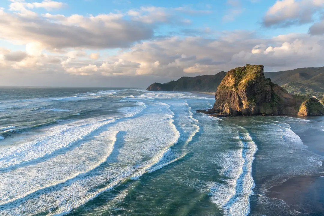
Bixby Bridge: Iconic arch (Highway 1 Mile Marker 62—1932 concrete open-spandrel arch 714 feet span 260 feet above Bixby Creek, vista pullout north side parking 10 cars difficult wait turnout, Instagram drone photography illegal $1,000 fine FAA restricted airspace, walk bridge narrow 24-foot width pedestrians dangerous traffic fast blind curve, sunrise 6:00am-7:00am optimal golden hour south lighting, fog June-August obscures frequently check webcams, allow 15-30 minutes photos traffic clears)
Hurricane Point Vista: Panoramic views (Highway 1 Mile Marker 65—720 feet elevation pullout both sides highway, 360° views coastline miles north/south, wildflowers April-May lupine poppies, fog layer below sometimes standing above clouds surreal, sunset 7:00pm-8:30pm summer backlit, allow 10-15 minutes pullout quick photos)
Afternoon: Pfeiffer Big Sur State Park Hiking + River (1:00pm-5:00pm)
Pfeiffer Big Sur: Redwood oasis (47225 Highway 1—$10 day use parking, 1,006 acres Big Sur River flows through, Valley View Trail 2 miles moderate elevation 300 feet redwood groves creek crossings overlooks valley, Pfeiffer Falls Trail 1.5 miles round-trip waterfall 60 feet seasonal December-May best flow, campground 189 sites $35 reserve six months advance sells out weekends, river swimming holes cold 55°F refreshing summer, picnic tables barbecues, allow 3-4 hours hiking swimming relaxing)
Evening: Big Sur Village Dinner + Sunset (5:00pm-8:00pm)
Big Sur Village: Lodge cluster (Highway 1 Mile Markers 47-48—Big Sur Lodge Pfeiffer State Park restaurant $20-$35 entrees breakfast/lunch/dinner, Deetjen's Big Sur Inn $200-$400/night historic 1930s cabins Norwegian immigrant Castro-style architecture candlelit no electricity atmosphere, Big Sur River Inn $180-$350/night restaurant $18-$30 deck over river outdoor seating, Village Pub $15-$25 burgers locals hangout, Maiden Publick House taproom $8-$12 craft beer, Ripplewood Cafe $12-$18 breakfast all-day, allow 1-2 hours dinner driving limited nightlife dark)
Day 1 costs:
- Gas Carmel fill-up: $60 (tank 12 gallons $6.50/gallon versus Monterey $5 save $18 but Carmel last chance)
- Point Lobos admission: $10
- Supplies grocery Safeway: $50 (cooler snacks/lunch/drinks/breakfast no stores 90 miles)
- Pfeiffer Big Sur day use: $10
- Dinner Big Sur Inn: $35
- Total: $165 (accommodation separate—camping $35-$75 reserve advance, lodges $300-$1,200)
Day 2: McWay Falls to Pfeiffer Beach Purple Sand to Nepenthe Sunset
Understanding Day 2 priorities:
Morning: Julia Pfeiffer Burns State Park McWay Falls (8:00am-11:00am)
McWay Falls: Waterfall beach (Highway 1 Mile Marker 37—$10 parking lot 20 cars arrive 8:00am-9:00am before fills or roadside $0 limited shoulder dangerous, Overlook Trail 0.6 miles paved wheelchair accessible waterfall drops 80 feet beach cove turquoise forbidden access beach closed erosion danger $1,000 fine trespassing, photography polarizing filter essential glare reduction, fog June-August obscures morning wait 11:00am-1:00pm burn-off or skip, tide high hides beach low exposes sand optimal, Pelton Wheel historical exhibit underwater turbine provided power homestead 1940s, allow 45-60 minutes trail photos crowds)
Ewoldsen Trail: Challenging hike (Julia Pfeiffer Burns—4.5 miles loop elevation 1,600 feet gain, redwood groves McWay Creek canyon, ocean overlooks dramatic cliffs views, switchbacks steep sections strenuous 3-4 hours, bring water 2 liters shade limited, allow 4-5 hours if hiking versus quick McWay Falls only)
Midday: Pfeiffer Beach Purple Sand (11:00am-3:00pm)
Pfeiffer Beach: Hidden gem (Sycamore Canyon Road Mile Marker 48—UNMARKED turnoff look brown sign "Pfeiffer Beach" only indicator blink miss, 2 miles gravel narrow one-lane pullouts opposing traffic, $12 parking lot honor system envelope, purple sand garnet mineral erodes cliffs manganese deposits unique, keyhole rock arch natural tunnel sunset iconic waves crash through, tide low explore caves high dangerous sneaker waves kill tourists annually warning signs respect, beach fires allowed below high tide line bring firewood, photography sunset 6:00pm-8:00pm summer golden hour arch frames sun May-July optimal angle, clothing optional north end unofficially tolerated, allow 3-4 hours relaxing exploring photography)
Afternoon: Partington Cove Trail + Limekiln State Park (3:00pm-5:00pm)
Partington Cove: Smuggler's tunnel (Highway 1 Mile Marker 41—parking dirt pullout 5 cars, trail 0.5 miles descent 200 feet wooden bridge creek tunnel through rock 1880s Partington Landing logging port redwood tanbark shipped, cove emerald water jade jade jade, tide pools low tide explore, rocky beach challenging access worth effort, allow 45-60 minutes hike exploring, keyhole sea arch visible offshore)
Limekiln State Park: Beach redwoods (63025 Highway 1—$10 parking, Limekiln Trail 1 mile waterfall 100 feet through redwoods Hare Creek, beach camping 22 sites $35 oceanfront, historic limekilns 1880s rockwork preserved, tide pools explore, allow 1-2 hours if time permits otherwise skip)
Evening: Nepenthe Sunset Dinner + Henry Miller Library (5:00pm-9:00pm)
Nepenthe: Legendary restaurant (48510 Highway 1 Mile Marker 45—$25-$50 entrees tourists locals mix since 1949 Orson Welles Rita Hayworth honeymoon cabin original, Ambrosia burger $25 famous avocado, terrace views 808 feet elevation Pacific coastline sunset, crowded 6:00pm-8:00pm wait 1 hour or earlier 5:00pm seating, Phoenix gift shop below, parking lot tight arrive early, allow 2-3 hours dinner sunset watching)
Cafe Kevah: Budget alternative (48510 Highway 1—below Nepenthe same ownership, $12-$20 breakfast/lunch lighter fare, outdoor terrace same views half price, closes 4:00pm so Nepenthe dinner only)
Henry Miller Library: Bookstore hangout (48603 Highway 1—$5 suggested donation, Beat Generation author lived Big Sur 1944-1962, books used/new Miller focus, concerts/film screenings/events community hub, free WiFi only reliable Big Sur get online, open 11:00am-5:00pm Wednesday-Monday closed Tuesday, allow 30-45 minutes browsing WiFi email)
Day 2 costs:
- Julia Pfeiffer Burns parking: $10
- Pfeiffer Beach parking: $12
- Lunch packed: $10 (from yesterday's Safeway supplies)
- Limekiln optional: $10
- Dinner Nepenthe: $40
- Total: $82 (light day hiking beaches nature)
Day 3: Esalen Hot Springs to Andrew Molera State Park to Carmel Return
Understanding Day 3 priorities:
Early Morning: Esalen Institute Hot Springs (1:00am-3:00am)
Esalen: Clifftop baths (55000 Highway 1 Mile Marker 14—$40 public access midnight-1:00am only 20 spots reservations required online esalen.org/page/public-baths-reservations opens 48 hours advance sells out minutes, clothing-optional natural hot springs 120°F mineral water cliffside massage tables ocean 100 feet below, spiritual retreat center $170-$3,000 workshops/lodging Aldous Huxley/Joan Baez/Hunter S. Thompson visited 1960s counterculture epicenter, middle-of-night timing inconvenient but only public access otherwise guests-only, stargazing Milky Way visible no light pollution, bring towel flashlight, allow 2 hours soaking if lucky reserve or skip if miss)
Morning: Andrew Molera State Park Beach Hike (9:00am-1:00pm)
Andrew Molera: Largest park (Highway 1 Mile Marker 49—$10 day use parking, 4,766 acres meadows redwoods beach, Creamery Meadow Trail 1 mile flat Big Sur River walk-in campground 24 sites $25 first-come hike 200 yards gear carts provided, Beach Trail 1 mile moderate through forest to beach secluded driftwood, Bluffs Trail 2.5 miles loop coastal headland views wildflowers spring, Molera Point overlook sea otters kelp forests, allow 3-4 hours hiking beach lounging peaceful)
Midday: Garrapata State Park Coastline + Soberanes Point (1:00pm-4:00pm)
Garrapata: Hidden beaches (Highway 1 Mile Marker 70 north Big Sur proper—free parking pullouts dirt, Soberanes Point Trail 2 miles loop rocky headlands sea otters harbor seals wildflowers April-May lupine poppies hillsides purple-orange, Garrapata Beach access multiple coves tide pools, no facilities primitive, locals prefer less crowded than Point Lobos, allow 2-3 hours trails exploring)
Afternoon: Carmel Return + Mission (4:00pm-6:00pm)
Carmel Mission: Historic landmark (3080 Rio Road—$12 admission, Mission San Carlos Borromeo del río Carmelo 1770 Father Junipero Serra California missions founder buried here, museum artifacts Native American Ohlone culture conversion controversial, gardens courtyard architecture Spanish Colonial, allow 45-60 minutes history architecture)
Carmel Beach: Sunset farewell (Ocean Avenue west end—white sand cypress trees Dog Beach off-leash allowed, sunset 7:00pm-8:30pm summer golden hour, free parking limited arrive 6:00pm or walk village, allow 45-60 minutes watching sun drop Pacific)
Day 3 costs:
- Esalen hot springs: $40 (if reserved)
- Andrew Molera parking: $10
- Garrapata free: $0
- Lunch packed: $10
- Carmel Mission: $12
- Dinner Carmel village: $35
- Gas return Monterey: $0 (filled Carmel Day 1)
- Total: $107
Total 3-Day Costs Breakdown
Budget breakdown:
Accommodation (3 nights):
- Camping budget: $35-$75/night × 3 = $105-$225 (Pfeiffer Big Sur/Andrew Molera—reserve six months advance sells out or dispersed BLM Nacimiento-Fergusson Road free primitive)
- Lodge budget: $200-$400/night × 3 = $600-$1,200 (Deetjen's/Big Sur River Inn/Ripplewood—historic character no luxury)
- Lodge mid-range: $400-$800/night × 3 = $1,200-$2,400 (Glen Oaks/Big Sur Lodge—comfort modern)
- Lodge luxury: $1,000-$3,000/night × 3 = $3,000-$9,000 (Ventana/Post Ranch Inn—infinity pools cliffside spas absurd wealthy)
Daily spending:
- Day 1: $165 (gas/supplies/parking/dinner)
- Day 2: $82
- Day 3: $107
- Total: $354
Car rental (if not own):
- Rental Monterey: $60-$100/day × 3 = $180-$300 (SUV recommended clearance dirt roads versus compact adequate Highway 1 paved)
- Gas: $60 (Day 1 fill-up 12 gallons $6.50-$7.00 Carmel lasts three days 120 miles round-trip 25 mpg)
Additional costs:
- Monterey/Carmel airport shuttle: $40-$60 (MRY airport versus SFO 2 hours north SJC 1.5 hours)
- Camping gear: $0 if own, $100-$200 rent REI (tent/sleeping bag/pad)
- Food supplies: $50 Day 1 Safeway, $50 additional Cambria south if heading north-south versus return Carmel
Grand total:
- Budget camper: $650-$900 (camping $225, food supplies $100, minimal restaurants $150)
- Mid-range lodger: $2,000-$3,000 (lodges $1,500, food/parking $400, car rental $300)
- Luxury splurge: $4,000-$10,000+ (Post Ranch Inn $9,000, fine dining $300+ daily, spa treatments)
What to Skip: Tourist Traps Avoid
Understanding overrated:
Hearst Castle if short time:
- 60 miles north San Simeon ($25-$36 tours—William Randolph Hearst estate 1920s opulent but 2+ hours tour time, Cambria village 8 miles south better lunch stop)
- Alternative: Skip unless history architecture obsessed, Big Sur nature focus
Jade Cove/Willow Creek:
- 60 miles south Gorda (jade hunting beaches—mostly picked over, dangerous cliffs access, locals gatekeep spots, Highway 1 south Gorda deteriorates rough)
Overdone Instagram spots:
- Bixby Bridge/McWay Falls (crowded sunrise/sunset—beautiful but 100+ photographers tripods elbow to elbow, go off-peak 10:00am-4:00pm fewer crowds or skip entirely Garrapata hidden alternative)
Local Tips: Insider Knowledge
Understanding Big Sur survival:
Best times visit:
- Fall: September-November (warmest clearest 70-80°F, fog minimal, fire season risk but beautiful)
- Spring: April-May (wildflowers lupine poppies, waterfalls flowing, 60-70°F moderate)
- Avoid: June-August fog (marine layer blankets coast mornings sometimes all day, cold 55-65°F), December-March rain (50-80 inches annually, landslides/closures Highway 1 unpredictable check Caltrans 511 before departing)
Driving tips:
- Slow down: 25-35 mph average (90 miles = 3-4 hours driving versus freeway 90 minutes, blind curves hairpin turns, cliffs no guardrails, motion sickness common passengers Dramamine)
- Pullouts: Use them (RVs/slow drivers required pull over let traffic pass, courtesy essential locals aggressive honk if blocking)
- Fuel: Carmel fill-up ($6.50-$7.00 last reasonable—Big Sur $7-$8 Gorda limited hours, no fuel 90 miles range anxiety real)
- Cell service: Spotty (AT&T weak, Verizon better but pockets only, download offline maps Google Maps before departing)
Safety warnings:
- Sneaker waves: Kill tourists (Pfeiffer Beach/McWay Falls—rogue waves crash higher than normal sweep people off rocks annually, never turn back ocean)
- Cliff edges: Unstable (erosion constant, fences protect stay behind, McWay Falls beach closed trespassing $1,000 fine dangerous)
- Wildlife: Mountain lions/rattlesnakes (rare but present, hike groups make noise)
Where to eat:
- Nepenthe: Tourist must ($25-$50—views justify, crowded but experience)
- Big Sur Deli: Locals secret (roadside $10-$15 sandwiches better value than restaurants)
- Pack supplies: Safeway Carmel (no grocery stores 90 miles, cooler essential, breakfast/lunch DIY saves $50+ daily)
Camping reservations:
- Book six months advance: Pfeiffer Big Sur/Andrew Molera (sells out weekends May-October, recreationgov.gov opens 6 months, alternative Kirk Creek $35 ocean views less popular)
Who Should Visit Big Sur: Realistic Assessment
Understanding fit:
Nature lovers:
- YES ABSOLUTELY: Unparalleled coastal beauty (redwoods+ocean combination rare, hiking trails waterfalls beaches pristine)
- Know: Fragile infrastructure (one road closes unpredictably, isolation complete, emergency helicopter only)
Photographers:
- YES: Golden hour endless (Bixby Bridge/McWay Falls iconic, wildflowers spring, fog drama, sunrise/sunset optimal but crowds)
Luxury seekers:
- YES IF BUDGET: Post Ranch Inn/Ventana ($1,500-$3,000/night—infinity pools cliffside spas massage ocean views absurd wealthy justify if afford)
Budget travelers:
- CHALLENGING: Camping possible $650-$900 three days (reserve advance, supplies Carmel, cook meals, skip restaurants mostly, doable with effort)
Road trip enthusiasts:
- YES: Highway 1 bucket list (90 miles most scenic America, winding challenging concentration rewarding, stop frequently pullouts)
Families with kids:
- MAYBE: Hiking beaches kid-friendly (Pfeiffer Big Sur River swimming, Andrew Molera beach trails, but long drives restless kids, limited kid-focused activities, expensive lodges)
Accessibility needs:
- LIMITED: McWay Falls paved (wheelchair accessible 0.6 miles, but most trails rugged narrow, lodges limited ADA, remote medical access)
Is 3 Days Enough? Honest Answer
Understanding limitations:
What 3 days covers:
- ✅ Highlights (Bixby Bridge/McWay Falls/Pfeiffer Beach/Nepenthe)
- ✅ Major parks (Julia Pfeiffer Burns/Pfeiffer Big Sur/Andrew Molera)
- ✅ Driving Highway 1 slowly (90 miles 3-4 hours savor pace)
What 3 days misses:
- ❌ Deep trail exploration (Ewoldsen/Salmon Creek/Vicente Flat 10+ miles backcountry)
- ❌ Hidden beaches locals protect (Jade Cove/Willow Creek/Mill Creek gatekept)
- ❌ Extended stays (Esalen workshops week-long $2,000+, New Camaldoli Hermitage silent retreat)
- ❌ South Big Sur (Gorda/Ragged Point/Hearst Castle 60+ miles south)
Recommendation:
- 3 days: Highlights sufficient (Bixby/McWay/beaches/parks—good overview introduction)
- 5-7 days: Comfortable pace (backpacking trails, hidden coves, multiple sunset spots Nepenthe/Pfeiffer Beach different nights, relax don't rush)
- Lifetime: Locals return (lifelong residents discover new spots decades living here, spiritual depth meditation)
Big Sur three days offers unparalleled beauty Highway 1 90-mile coastline Santa Lucia Mountains drop 5,000 feet ocean cliffs, Bixby Bridge 1932 arch 714 feet span Instagram iconic, McWay Falls 80 feet waterfall turquoise cove Julia Pfeiffer Burns $10, Pfeiffer Beach purple sand garnet keyhole rock arch sunset $12, redwood forests Pfeiffer Big Sur State Park trails Big Sur River, Nepenthe restaurant $25 Ambrosia burger terrace views sunset 808 feet elevation since 1949, Andrew Molera 4,766 acres meadows beach trail secluded, Point Lobos sea otters kelp forests $10 appeal to those accepting extreme costs ($2,000-$3,000 mid-range lodges $300-$800/night or camping $35-$75 reserve six months advance, restaurants $25-$50 captive market limited 15 total, gas $6-$7 Carmel versus $5 Monterey 20% markup), infrastructure fragile (one road Highway 1 closes winter landslides 2017 Pfeiffer Canyon 13 months, cell service spotty Verizon pockets AT&T weak, no grocery stores 90 miles Carmel north Cambria 60 miles south stock Safeway supplies), narrow winding exhausting (25-35 mph average 90 miles = 3-4 hours concentration, blind curves hairpin turns, cliffs 500+ feet no guardrails, motion sickness common Dramamine), weather unpredictable (fog June-August marine layer obscures mornings, rain December-March 50-80 inches landslides, fall September-November optimal 70-80°F clear), and recognition 90-mile stretch protected California Coastal Commission development restricted zoning 1 dwelling per 20-40 acres locals 4,000 fiercely protective sacred. Day 1 Carmel/Point Lobos/Bixby/Pfeiffer Big Sur, Day 2 McWay Falls/Pfeiffer Beach/Nepenthe sunset, Day 3 Esalen/Andrew Molera/return covers essentials driving Highway 1 slowly savoring. Nature lovers/photographers thrive, luxury seekers Post Ranch Inn $3,000+ justify views, budget campers possible $650-$900 effort reserves advance supplies DIY meals.
Big Sur three days shows highlights accepting extreme costs infrastructure fragile isolation complete understanding 90-mile wilderness requires weeks return spiritual depth meditation locals lifetime discover protecting sacred hidden spots never publicize.