Top 10 "Hidden Gem" Road Trip Destinations in the USA
Michael Reynolds • 05 Mar 2026 • 250 views • 5 min read.Let me tell you how I am defining "hidden gem" for this guide, because the term has been applied so broadly in travel content that it has nearly lost meaning — and the definition changes which destinations qualify. A hidden gem for road trip purposes means a destination that delivers experiences comparable in quality to the famous alternatives with meaningfully less crowd density, lower cost, and the specific pleasure of feeling like you discovered something rather than completing a checklist. It does not mean completely unknown — truly unknown destinations often lack the infrastructure that makes a road trip enjoyable. It means systematically undervisited relative to their quality, which is a more useful category than simply obscure. The test I am applying to each destination: if you described the experience to someone who had just visited the famous equivalent, would they recognize comparable quality? If a Yellowstone visitor would recognize the geothermal landscape description but find Craters of the Moon genuinely different and compelling, Craters of the Moon qualifies. If a Great Smoky Mountains visitor would recognize the Appalachian landscape but find the Bankhead National Forest genuinely wilder and less developed, Bankhead qualifies. With that framework in place, here are ten destinations that pass the test — with specific information about what makes each worth the drive.
Top 10 "Hidden Gem" Road Trip Destinations in the USA
One: The Palouse, Eastern Washington and Idaho
The Palouse is a region of rolling agricultural hills in eastern Washington and northern Idaho that produces some of the most photographically striking rural American landscape you can drive through — undulating hills of wheat, lentils, and canola in colors that shift from winter's brown through spring's vivid green to harvest's gold, photographed from the famous Steptoe Butte viewpoint that provides a three hundred sixty degree panoramic of the rolling hills extending to every horizon.
The region receives a fraction of the attention of Washington's Olympic Peninsula or North Cascades despite offering landscape photography opportunities that attract professional photographers from across the country. The small towns — Pullman (home to Washington State University), Moscow Idaho, Colfax, Palouse — provide the practical infrastructure of accommodation and food without the tourist infrastructure pricing of more famous destinations.
Pro Tip: The Palouse is at its most visually spectacular in two windows: late April through May when the winter wheat is intensely green before heading out, and late July through August when the harvest creates the geometric patterns of cut and standing grain that make the landscape look painted. Visit during these windows rather than outside them — the visual reward is the entire point.
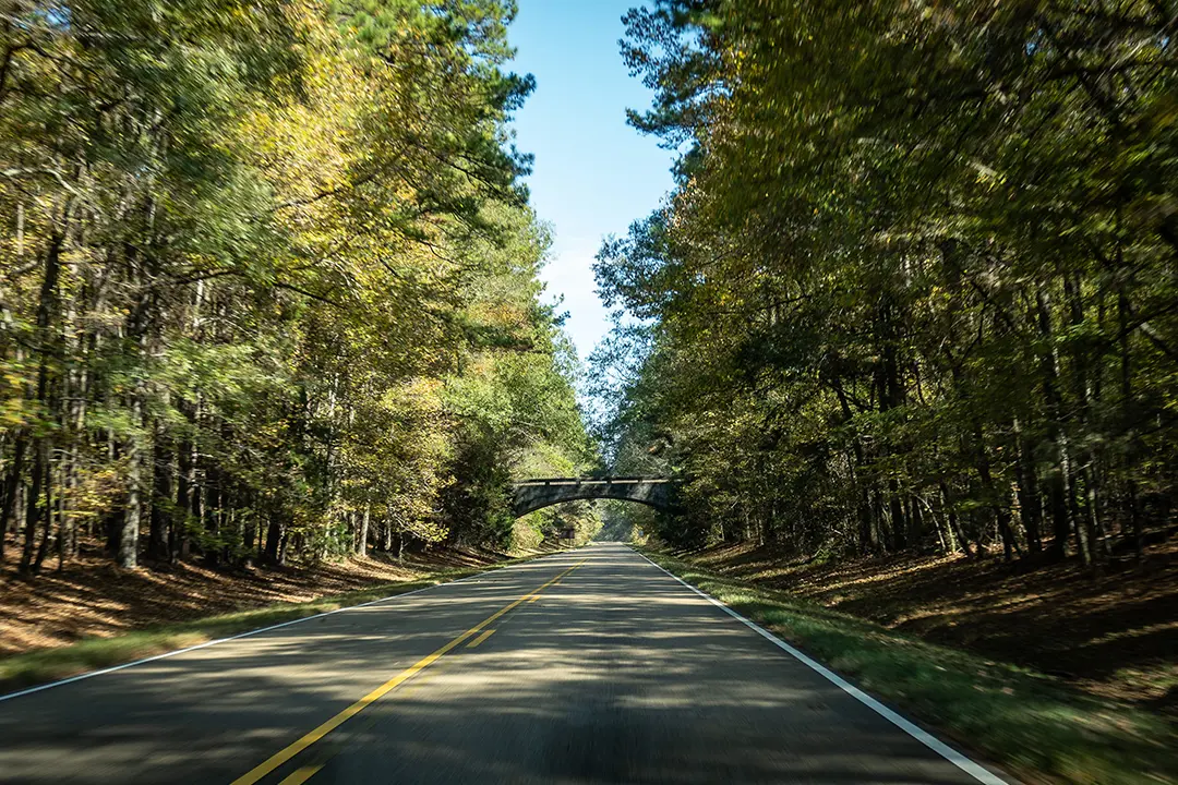
Two: Natchez Trace Parkway, Mississippi to Tennessee
The Natchez Trace Parkway is a four hundred and forty-four mile National Park Service parkway following the historic Natchez Trace trail from Natchez, Mississippi to Nashville, Tennessee. The parkway has no commercial vehicles, no billboards, and no traffic lights — just continuous forest, meadow, and historical site access on a road maintained to National Park standards.
The Trace passes through terrain that most Americans who have not driven it would not associate with Mississippi and Alabama — deep hardwood forest, river bottomland, cypress swamps, and the specific quiet of a road designed for contemplative travel rather than efficient transit. The historical sites along the route — Native American mounds, Civil War sites, frontier-era stands and inns — are accessible without the crowds that comparable sites in more visited parks attract.
Warning: The Trace's fifty miles per hour speed limit is strictly enforced and non-negotiable. This is not a road for drivers who want to cover distance quickly. Budget two to three days for the full length if you want to stop at the historical sites rather than just drive through.
Three: Craters of the Moon National Monument, Idaho
Craters of the Moon is a volcanic landscape of lava flows, cinder cones, and lava tube caves in central Idaho that looks, genuinely, like nothing else in the continental United States. The monument covers over seven hundred thousand acres of the Great Rift volcanic zone — one of the most recently active volcanic areas in the lower forty-eight, with its last major eruption approximately two thousand years ago.
The draw for road trip visitors: a landscape of stark, alien beauty that requires no hiking to access, with the monument's Loop Road providing eight miles of easy driving access to cinder cone overlooks, lava tube cave entrances (bring headlamps — the caves are accessible with standard equipment), and spatter cone fields. The monument receives approximately three hundred thousand visitors per year — comparable to a single busy weekend at Yellowstone.
Four: Marfa, Texas and the Trans-Pecos
Marfa is a town of approximately two thousand people in the high desert of far West Texas that has become, through a combination of Donald Judd's minimalist art installations, the mysterious Marfa Lights phenomenon, and the specific character of the Chihuahuan Desert landscape, one of the most unusual road trip destinations in the country — a place where contemporary art, frontier history, and vast empty landscape exist in genuinely unexpected combination.
The surrounding Trans-Pecos region includes Big Bend National Park (the most remote and least-visited major National Park in the lower forty-eight), the Davis Mountains and McDonald Observatory (one of the best dark sky observing sites in the continental US accessible by road), and Palo Duro Canyon (the "Grand Canyon of Texas" — a canyon system of comparable visual drama at a fraction of the Grand Canyon's visitor volume).
Pro Tip: The drive from Marfa to Big Bend through Presidio and along the Rio Grande on FM 170 — the "River Road" — is one of the most spectacular drives in the United States and one of the least known outside of dedicated West Texas travelers. The road follows the Rio Grande through volcanic canyon country with views into Mexico that have no equivalents on the more-traveled Texas roads.
Five: The Olympic Peninsula's East Side, Washington
The Olympic Peninsula's western side — Hoh Rain Forest, Rialto Beach, the coastal wilderness — receives most of the peninsula's visitor attention and is genuinely spectacular. The eastern side of the peninsula, along Hood Canal, is a different and equally compelling landscape that receives a fraction of the western side's visitors.
The Hood Canal area combines cold-water recreational opportunities (oyster harvesting from roadside stands, salmon fishing, scuba diving with remarkable visibility in the cold water), old-growth forest access through the Olympic National Forest, and views across the canal to the Olympic Mountains that are available from campgrounds and beaches without the permit system and trail registration required for the western wilderness areas.
Six: Bankhead National Forest, Alabama
Bankhead National Forest in northwestern Alabama protects one of the largest contiguous tracts of old-growth hardwood forest in the southeastern United States, centered on the Sipsey Wilderness — Alabama's only federally designated wilderness area — and the Sipsey Fork of the Black Warrior River, whose sandstone canyon walls and swimming holes are among the best-kept secrets in southern outdoor recreation.
The specific draw: canyon country that most Americans do not associate with Alabama. The Sipsey Fork cuts through sandstone geology that produces overhanging bluff shelters, waterfalls, and swimming holes in a landscape that reads as somewhere between the Ozarks and the Daniel Boone National Forest in Kentucky rather than the flat-terrain Alabama of the popular imagination.
Seven: Custer State Park, South Dakota
Custer State Park is the argument that South Dakota beyond Mount Rushmore and the Badlands is worth substantial road trip time in its own right. The park covers seventy-one thousand acres of Black Hills granite, prairie, and mixed forest that contains a free-roaming bison herd of approximately fourteen hundred animals — one of the largest in the world — accessible from the Wildlife Loop Road that produces wildlife encounters comparable to anything in more famous western parks.
The park's infrastructure — campgrounds, cabins, the four historic stone lodges — is excellent and priced significantly below comparable National Park accommodations. The Needles Highway and Iron Mountain Road within the park are engineering achievements and scenic drives of the first order that receive minimal attention relative to the Badlands Loop and Rushmore circuit that most South Dakota itineraries prioritize.
Warning: Bison on the Wildlife Loop Road are genuinely wild animals that occasionally block traffic, approach vehicles, and have injured visitors who approached too closely for photography. Stay in your vehicle or maintain at least one hundred feet of distance. A bison encounter from a car is spectacular and safe. A bison encounter at selfie range is neither.
Eight: Upper Peninsula Waterfall Country, Michigan
The Upper Peninsula of Michigan's western section — roughly the area between Munising and the Wisconsin border — contains more waterfalls per square mile than any comparable area in the eastern United States outside of the Smoky Mountains, including Tahquamenon Falls (one of the largest waterfalls east of the Mississippi), Miners Falls, Laughing Whitefish Falls, and dozens of smaller cascades accessible from forest roads.
The area is on Lake Superior's southern shore, which provides cold, remarkably clear freshwater beaches at Pictured Rocks National Lakeshore — a seventeen-mile stretch of sandstone cliffs, arches, and colored mineral streaks accessible by kayak or boat tour that has no visual equivalent in the eastern US.
Nine: Enchanted Rock and the Texas Hill Country Circuit
Central Texas's Hill Country between Austin and San Antonio contains one of the most accessible and undervisited outdoor recreation landscapes in the country — spring-fed swimming holes, cypress-lined rivers, and the massive pink granite dome of Enchanted Rock State Natural Area that rises three hundred and twenty-five feet above the surrounding terrain and is accessible via a moderate two-mile round trip trail.
The Hill Country circuit — Fredericksburg, Luckenbach, Kerrville, Wimberley, New Braunfels — combines German Hill Country heritage (Fredericksburg's main street is a genuine artifact of nineteenth-century German immigrant settlement, not a recreation), the Guadalupe and Comal rivers for tubing and kayaking, and wine country development that has made the region a legitimate wine destination over the past decade.
Ten: Apostle Islands National Lakeshore, Wisconsin
The Apostle Islands are a group of twenty-one islands off the Bayfield Peninsula in northwestern Wisconsin that provide sea kayaking, sailing, and island camping on Lake Superior at a scale and quality comparable to Maine coastal island experiences at a fraction of the visitor density.
The specific draw: twenty-one islands with caves, sea arches, and old-growth forest accessible by kayak or water taxi from Bayfield. In winter — a specific seasonal phenomenon — the sea caves ice over and become accessible on foot across the frozen lake when conditions allow, producing ice cave formations of extraordinary visual character. The ice cave season is weather-dependent and variable, but when conditions are right, it draws visitors from across the Midwest who would otherwise never encounter northern Wisconsin.
Hidden Gem Road Trip Destinations Compared
| Destination | State | Drive from Nearest Major City | Best Season | Crowd Level | Accommodation | Highlight |
|---|---|---|---|---|---|---|
| The Palouse | WA/ID | 5 hrs from Seattle | April-May, July-Aug | Low | Small town hotels | Agricultural landscape photography |
| Natchez Trace Parkway | MS-TN | Variable — linear route | Oct-Nov, March-April | Low-Medium | Towns along route | Historic road, no commercial traffic |
| Craters of the Moon | ID | 3 hrs from Boise | May-Sept | Low | Arco, ID nearby | Volcanic landscape, lava tube caves |
| Marfa + Trans-Pecos | TX | 6 hrs from San Antonio | Oct-April | Low | Marfa hotel/camping | Art + desert + Big Bend access |
| Olympic Peninsula East | WA | 2 hrs from Seattle | Year-round | Low | Hood Canal lodges | Old growth + Hood Canal oysters |
| Bankhead National Forest | AL | 2 hrs from Birmingham | March-May, Sept-Nov | Very Low | Nearby towns | Canyon swimming holes, old growth |
| Custer State Park | SD | 1 hr from Rapid City | May-Sept | Medium | Park lodges, camping | Bison herds, Needles Highway |
| UP Waterfall Country | MI | 5 hrs from Detroit | May-Oct | Low-Medium | Munising lodges | Waterfalls + Pictured Rocks cliffs |
| Enchanted Rock + Hill Country | TX | 1.5 hrs from Austin | March-May, Oct-Nov | Medium | Fredericksburg hotels | Swimming holes + granite dome |
| Apostle Islands | WI | 3 hrs from Minneapolis | June-Sept (kayak), Jan-Feb (ice caves) | Low | Bayfield B&Bs | Sea kayaking + ice caves |
Frequently Asked Questions
How do I find genuinely hidden gem destinations rather than ones that have already been discovered and written about extensively?
The destinations in this guide are genuinely less visited than their quality warrants but are not unknown — they appear in National Park Service visitor statistics, regional travel guides, and outdoor recreation communities. The approach that finds the next tier of genuinely undiscovered destinations: talk to rangers and locals at the places you visit and ask where they go when they want to be alone in nature. Rangers at famous parks often know the overlooked adjacent areas that provide comparable landscapes without the crowds — a Yellowstone ranger will tell you about areas of Wyoming and Idaho that deliver geothermal and wildlife experiences at a fraction of the visitation. The AllTrails and iOverlander apps surface user-reported lesser-known areas that have not yet reached mainstream travel content. State parks in states adjacent to famous national parks are the most consistently underused category — they share the same geology, ecology, and landscape as the famous parks with dramatically lower fees and visitor numbers.
What is the best time of year for a road trip that avoids peak crowds at even the hidden gem destinations?
The shoulder seasons — late September through October and April through May — consistently deliver the best combination of weather, color, and crowd avoidance across most of the continental US. October specifically is the road trip month with the best risk-adjusted experience: fall foliage in the eastern half of the country, cooling temperatures in the desert southwest that make previously heat-limited destinations accessible, and visitor numbers that drop dramatically after Labor Day even at famous destinations and essentially disappear at the hidden gems in this guide. April and May deliver wildflower seasons in Texas, desert bloom in the southwest, and the specific vivid green of spring foliage in the east before summer haze. The specific caveat: shoulder season weather is more variable and requires more preparation for unexpected conditions than the predictable summer season — pack for temperature swings and have a flexible itinerary that can adapt to weather rather than a fixed daily schedule.
How do I plan a road trip that connects multiple destinations in this guide efficiently?
The geographic clustering that makes multi-destination road trips efficient: the Pacific Northwest cluster (Olympic Peninsula East, the Palouse) can be combined in a week-to-ten-day loop from Seattle. The Texas cluster (Marfa, Trans-Pecos, Enchanted Rock, Hill Country) makes a compelling ten-to-fourteen day Texas road trip from any Texas entry point. The Midwest cluster (Custer State Park, Apostle Islands, Upper Peninsula waterfall country) forms a two-week Great Lakes and Northern Plains circuit from Chicago or Minneapolis. The southeastern destinations (Natchez Trace, Bankhead) form a natural pairing for an Alabama-Mississippi-Tennessee circuit accessible from Atlanta or Nashville. The Idaho destinations (Craters of the Moon, and Palouse if extended) form a natural loop through southern Idaho. Planning within clusters rather than attempting cross-country connections between all ten destinations produces the most efficient trip structure.
The ten destinations in this guide share a specific characteristic that distinguishes them from the famous alternatives they complement: they deliver genuine quality experiences — visual drama, wildlife encounters, historical depth, or recreational excellence — at visitor volumes that allow you to actually experience the place rather than photograph it in the company of thousands of other people doing the same thing.
The Palouse's rolling hills, the Trace's commercial-free parkway, Craters of the Moon's volcanic otherworldliness, Marfa's improbable art-in-desert combination, the UP's waterfall country, Bankhead's canyon swimming holes, Custer's bison herds, the Apostle Islands' sea caves, the Hill Country's spring-fed rivers — none of these require reservations made six months in advance, none produce the parking lot experience that the famous parks deliver in peak season, and all of them deliver the specific road trip pleasure of feeling like you found something worth finding.
Start with the cluster closest to where you are.
Drive slowly.
Ask the ranger where they go on their days off.
The best hidden gems are the ones you discover one conversation at a time.